
Sermersuuaq – the great ice

We leave Tasiilaq and continue southwards. Our destination for today: a sheltered bay off Hornemann Island. We intend to drop anchor there.

Towards evening, we make our way cautiously into the bay: numerous icebergs have drifted in here, requiring skilful evasive manoeuvres. We also have to keep a close eye on our depth gauge at all times – the water depth would only allow us to anchor close to the shore cliffs, but it drops off sharply there. The rear part of the bay is still completely frozen over, with a sheet of ice around 60 cm thick resting on the water’s surface. It quickly becomes clear that the best mooring spot for tonight is the ice edge. We glide slowly towards the edge with Dagmar Aaen, haul the anchor onto the ice, dig it in – and the ship is securely moored.

Now is the time to take a closer look at this bay. Around 20 seals are lying on the vast expanse of ice before us. Curiously, they glance over at us every now and then. But as idyllic as this may seem at first glance, where there are seals, polar bears are usually not far away – for them, this is a perfect place to hunt. And we cannot rule out the possibility that they might pay a visit to our ship. This means we’ll be keeping watch over the anchor and on the lookout for bears tonight.

Inland ice within sight

When we turn round, we can see the Greenland ice sheet about 15 kilometres away. This vast mass of ice glows white before us. We stand before a magnificent natural phenomenon and, at the same time, before a highly sensitive climate system, the condition of which has serious consequences for the global climate.

The ice sheet covers more than 80 per cent of Greenland’s total area and measures around 1.8 million square kilometres. The ice is on average around 2,000 metres thick – in some areas it is as much as 3,000 metres. It stretches more than 2,500 kilometres from north to south, which is as far as the distance from northern Germany to North Africa. The ice stores enormous quantities of fresh water; its volume is estimated at 2.8 million cubic kilometres. A quantity that is almost impossible to imagine. The average annual temperature at the ice surface is -32 degrees; the altitude and the reflection of thermal radiation protect the ice.

In the Inuit language, ‘Sermeq’ means glacier and ‘suaq’ means large. ‘Sermersuaq’ – the great ice – is the Greenlandic name for the inland ice sheet, as far back as people here can remember.

Melting process already underway

But how long this will remain the case is uncertain. Between 2011 and 2014 alone, the ice sheet lost an average of around 269 billion tonnes of ice per year, according to a study by Malcolm MacMillian published in 2026. Climate researchers warn that global warming of more than three degrees could lead to the complete melting of the Greenland ice sheet. Sea levels would then rise by approximately 7.20 metres. One consequence of this melting would be, amongst other things, a significant reduction in the inflow of warm water into the North Atlantic, as the increased influx of melted ice would raise the proportion of fresh water, thereby disrupting thermohaline circulation and the Gulf Stream system.

The timeframe over which the melting process will unfold, and whether stabilisation can even be achieved once critical thresholds have been exceeded, depends on many factors. The fact is that the inland ice is already shrinking and its thickness is decreasing – more ice is melting than is being replenished by annual snowfall. And as it is not as cold at lower altitudes, this process is likely to accelerate further and further. Furthermore, dust and dirt particles settle on the ice and hinder heat reflection – with the result that the dark regions on the ice melt significantly faster than the gleaming white ice surface.

Observe, analyse, understand

These are just two alarming processes, alongside global warming, which pose a massive threat to the existence of the Greenland ice sheet. The ice off our anchorage is an important piece of the jigsaw in a highly complex and sensitive climate system. We are observing these changes and collecting scientific data to draw attention to these processes and to understand them.

But for tonight on the Dagmar Aaen, the order of the day is: bear watch!

Uli Weih
Greenland and the ‘Red House’

A visit to the ‘Red House’

It takes the Dagmar Aaen just under three days to make the crossing from Iceland to Greenland – for us, this time it meant three days on the North Atlantic with moderate weather, favourable winds and plenty of whale sightings. As we reach the East Greenland Current, the water temperature drops to around two degrees and the first icebergs appear. Gigantic white colossi on their way south. As fascinating as these floating giants are, a collision would be fatal. That means we must always be on our guard and take evasive action in good time.

We finally drop anchor off the settlement of Tasiilaq. Greenland welcomes us with blue skies, plenty of sunshine and a mild 6 degrees. An Arctic summer!

A journey through the white desert

Here in Tasiilaq, we plan to meet Robert Peroni – the man who, in 1983, together with Pepi Schrott and Wolfgang Thomaseth, was one of the first to cross the Greenland ice sheet at its widest point. The three men were on the move for 88 days, without any further aids or supply depots. 1,400 kilometres through the white desert, constantly on their guard against the treacherous ice and the threat of bears. An immense ordeal. But also a formative experience for Peroni: the extreme sportsman discovered his fascination with the Arctic, the people of Greenland and life in the far north.

He still lives in Tasiilaq today, where he runs the ‘Red House’. A guesthouse for visitors, a meeting place for people from different cultures, and a focal point for many residents of Tasiilaq.

Hunting culture meets globalisation

He deliberately employs only Greenlanders, providing people with work and – even more importantly – prospects for life and the future. For the social problems in Greenland are immense. It was not until 1982 that East Greenland was opened up to the international community – that is to say, the first tourist was allowed to enter without a permit. Only since then has this region slowly begun to open up. Until then, the vast majority of people in Greenland lived in isolation and had hardly any contact with the rest of the world. Yet for many people in Greenland, the influx of globalised modernity into the traditional hunting culture happened far too quickly and was almost impossible to come to terms with.

With his ‘Red House’, Robert Peroni is trying to encourage the Inuit and show them sustainable ways forward that preserve their culture whilst still offering them a future. He now employs up to 70 people from Tasiilaq, whether as guides, boat skippers or hostel staff. There are now around 60 accommodation options for tourists who want to explore East Greenland and get to know the people here.

Robert is now over 80 years old and is working hard to ensure that the “Red House” can continue to operate even without him. Unfortunately, this is rather complicated due to Greenlandic tax law. At least, since 2023, there has been “The Red House Greenland Foundation”, which is intended to ensure its continued existence. We’re certainly keeping our fingers crossed for this project!

Uli Weih

Vestmannaeyjar and Reykjavík

Heimaey is the name of the only village and harbour on the Westman Islands (Vestmannaeyjar). The name probably originates from the Vikings, who are said to have been the first to reach the islands and settle there. In 1973, the archipelago was rocked by a volcanic eruption. The inhabitants had to be evacuated, and it was only with great difficulty that the approach to the harbour was cooled with seawater and kept clear of the lava flow. Several houses were buried, but fortunately there were no loss of life. A museum well worth a visit recounts the dramatic events that unfolded during the volcanic eruption… Today, the harbour is considered the safest on Iceland’s south coast – and as a result, the fishing industry has established a key base here. A visit to the island is definitely worthwhile. The walk along the volcanic crater, the puffins nesting in the cliffs – and the very friendly and helpful islanders. A truly impressive island – even by Icelandic standards.

From the Westman Islands, the journey continues to Reykjavík. Strong winds are forecast. As we set sail, we’re met by gusts of 42 knots from the east. That’s certainly a lot of wind, but at least the direction is right. Once we’ve fought our way clear of the harbour approach, we set a westerly course. Under a triple-reefed mainsail, along with the jib and staysail, we make good headway against the wind and waves. We make good progress. It is not until late in the evening that the wind slowly dies down, and during the night we round the Reykjanes Peninsula and sail into the large bay at the end of which Reykjavík lies. At 9.30 am, we enter the harbour and moor directly beneath the Harpa, Reykjavík’s impressive concert hall.

A first-ever match between the Faroe Islands and Iceland

  • Bilder-Galerie:
    • Bilder:

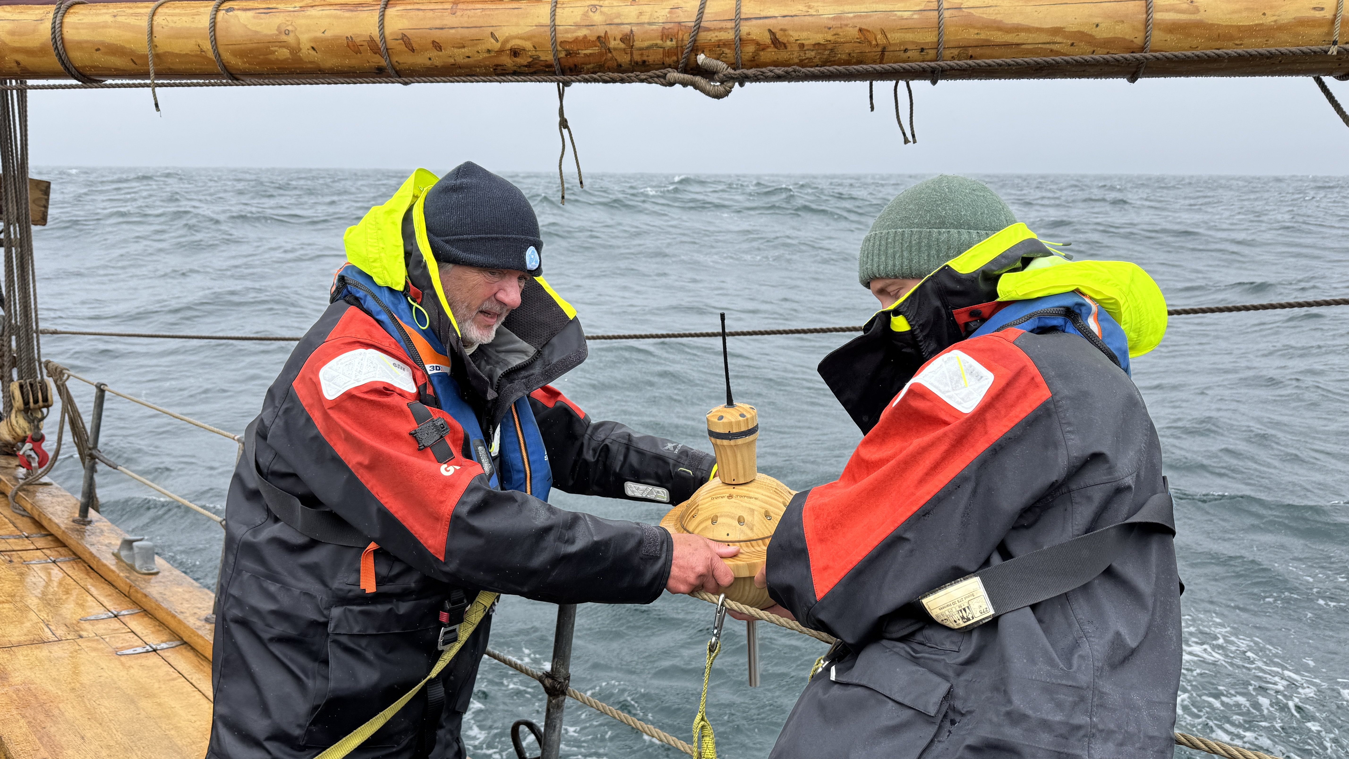
The Dagmar Aaen has been operating as a volunteer weather observation vessel since the early 1990s. Back then, data was still recorded manually and transmitted by radio. Today, we have a fully automated weather station on board which sends the latest data via satellite every hour. We can manually enter observations such as cloud cover and wave heights, etc.

In recent years, we have also repeatedly deployed measuring buoys for the German Weather Service (DWD) and Météo France. These buoys operate completely autonomously for around 2–3 years whilst drifting across the oceans, continuously transmitting weather data to the relevant authorities. This data is then incorporated into daily weather forecasts, including, for example, the marine weather report. Weather forecasts can only be as accurate as the data on which they are based. The more measuring stations there are, the more precise the forecasts.

However, these drifting buoys are made of plastic, which has always left us feeling uneasy when we’ve deployed them overboard. Even more plastic in the oceans! Even if it is for a good cause. Arved’s suggestion to build the buoys out of wood was initially met with surprise – then with enthusiasm. The result is a joint European effort: the concept and electronics by E-Surfmar and Météo France, the electronics manufactured by CLS in Toulouse, the wooden body by the Bremen woodturning workshop, and data transmission via the new European satellite system Kineis. The DWD is actively involved in its further development. We now have one of these prototypes on board and are deploying it between the Faroe Islands and Iceland – this is the first time that such a buoy has been tested under real-world conditions in the North Atlantic. We wish it a long service life and many successful data transmissions, so that more of its kind can be built...

Stopover: Orkney

The start of Ocean Change 2026 was a gentle one. Setting off from Kiel, the journey took us first through the North-East Canal, with overnight stops in Rendsburg and Brunsbüttel, before we sailed on from there to Heligoland. This was ideal for the crew – everyone had a chance to settle in and get used to the trip. Watch duties were allocated, the safety briefing was carried out and, finally, our doctor Sarah conducted a thorough medical briefing in Heligoland harbour. It has become a lovely tradition whenever the Dagmar Aaen visits Heligoland for the crews of the locally stationed rescue cruiser Hermann Marwede, the DGzRS and the Dagmar Aaen to invite one another for a reciprocal visit. The rescue cruiser is impressive. The rescuers, always modest, do an incredible job. During the night they were out rescuing a stricken sailor with a broken mast; first thing the next morning they had to set off on another mission. We all have the utmost respect for the work of the DGzRS in all weathers. It is funded by donations – which is why every donation is extremely welcome.

The first leg of the voyage takes us from Heligoland to the Orkney Islands in the north of Scotland. That’s around 500 nautical miles diagonally across the North Sea. The weather is capricious and changeable; the ship is pitching hard into the wind, spray is coming over the deck, and some of the crew have become a bit quiet – seasickness has reared its head. There are three watches. From midnight to 4 am is the so-called ‘dog watch’, from 4 am to 8 am is the morning watch, and from 8 am to 12 noon. Then it all starts again. Each watch consists of the watch leader and one or two other crew members. The skipper and Richard, the cook, are off watch; he regularly provides the crew with fantastic meals. He enjoys cooking vegetarian and vegan dishes – everyone loves them.

On 12 June, we arrive in Kirkwall amid persistent rain and gusty winds. We’d registered with the harbour in good time, and as we sail in, two mooring attendants are already on shore to take our lines. The first leg of our sea voyage is behind us.

The Orkney Islands are special. In conversations with the islanders, you hear time and again that they actually feel more connected to Norway than to the UK. This has historical roots and is linked to the Vikings, who once shaped life here. The Neolithic settlement of Skara Brae dates back 5,000 years. This impressive settlement is open to the public as an archaeological site. Stone circles and ancient burial sites bear witness to the early culture on the islands. Modern Orkney generates 130 per cent of its electricity requirements from renewable energy sources; the surplus is exported to the mainland. We are visited by Ian, the owner of ‘Orkney Odyssey’. Among other things, he leads and organises ‘Renewable Energy Tours’. He tells us about the tidal power stations, trials with wave power stations and other projects. The surplus electricity is to be used to run a large-scale hydrogen production facility, and the local population is fully behind the initiative – here, people want nothing to do with fossil fuels or nuclear power. New standards are being set here!